In its first twelve years, the MCWD focused on its founding mandate to address flooding issues and plan for the reconstruction of the Gray’s Bay dam. The MCWD formed a joint powers group with cities along Minnehaha Creek to advance a vision of uniform land use, flood plain management and a development guide while also obtaining federal funds to acquire 42 parcels for open space along the Creek. Invited by cities to review land use development for water resource impacts, the MCWD developed its first regulatory program. Monitoring data collection commenced from the District’s inception, and the MCWD obtained funding from the federal Environmental Protection Agency to develop a groundbreaking computer model to plan for retention projects in the upper watershed.
The MCWD’s early years reflected a strong commitment to partnership with cities in the watershed in planning and regulatory matters. The District’s commitment to public education and outreach was reflected in the creation and active work of a 48 member advisory committee. Cities were deeply engaged in the preparation of the District’s first overall plan, and initiated the District’s first major capital projects, including the Gray’s Bay Dam, numerous creek improvements, and the Upper Watershed Retention Project.
This article is excerpted from MCWD’s Historic Insights and Principles of Success publication, compiled by its Board of Managers and staff as part of a process to evaluate key events over time, extract strategic insights, and document learnings that could be carried forward to guide the future success of the organization.
Impetus and Establishment of the District
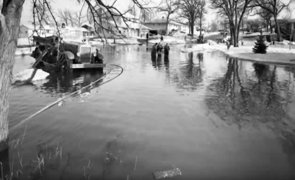
Serious flooding problems in 1966 prompted Minneapolis residents and city officials to request a watershed district for the purpose of seeking improved flood control. The result was that Hennepin County filed a petition to establish the Minnehaha Creek Watershed District on April 12, 1966. The Minnesota Board of Water Resources held a public hearing on the petition on December 12 and 13, 1966 at the Prudential Insurance building on Wayzata Boulevard in Minneapolis.
On March 9, 1967, the Board of Water Resources issued its order to establish the District, noting the severe flooding conditions along the Creek, increasing urbanization causing runoff, removal of natural land cover causing soil erosion and impacting water resources, the impact of public roads on stormwater runoff among the reasons to establish the District. The order established the first Board of five managers, one from Carver County, and four managers from Hennepin County.
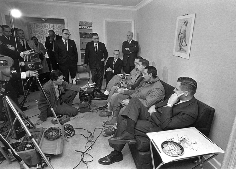
The Board of Managers devoted considerable effort in the early years to building an advisory committee which had 48 members and included local government officials and citizens with an interest in the watershed. The District prepared a slide show to educate the public about the watershed, created a public relations committee and an inspections committee, and organized a “Minnehaha Creek Appreciation Day,” which in 1973 involved gathering public officials, news media and citizens in 200 canoes to paddle the creek.
Strong working relationships with the elected officials and staff of cities in the watershed were central to the work of the District in this early period. The Board of Managers relied heavily on city partners in the planning for Minnehaha Creek, development of the District’s overall plan, and its regulatory program.
Minnehaha Creek Corridor Planning
St. Louis Park, Hopkins and Minnetonka initiated an important project for the District in 1969 to pursue a multi-community development plan for Minnehaha Creek. The District developed a joint powers agreement with these cities and the parties pledged to promote uniform land use planning for the Creek corridor, uniform flood plain ordinances, and a general development guide. In 1970 the Creek joint powers group began the process of seeking federal funds to acquire areas along the Creek to be set aside and remain undeveloped. Ultimately in 1971 this effort resulted in a grant from the federal Department of Housing and Urban Development of $383,300 which facilitated the acquisition of 11 parcels in St. Louis Park, 13 parcels in Hopkins, and 18 parcels in Minnetonka.
Edina formally joined the group of cities working with the District on cooperative development of a floodplain map for the Creek corridor. This group of cities later would become the organizing forum to develop a petition for the Grays Bay Dam and other improvements to Minnehaha Creek.
Regulatory Program
Almost immediately upon the formation of the District, the Board of Managers began to receive requests from cities and other local units of government as well as developers seeking technical review of land development and infrastructure projects. The District’s engineer provided technical review of the flooding and other water resource impacts of a proposed project, and these comments were in an advisory posture. The District also invested in providing recommendations to cities on ordinances to protect floodplains and other water resources.
By 1971, the District developed its own rules requiring permits from the District for many land disturbing activities, and later amended the rules in 1974. These rules were largely based on established standards promulgated by the Department of Natural Resources (DNR) and adapted to suit the needs of the District. Road projects, housing and commercial developments, and requests for dredging Lake Minnetonka constituted the majority of projects seeking a District permit. The District worked extensively with the Lake Minnetonka Conservation District and the DNR to develop dredging standards in order to protect the riparian environment and littoral zone of the lake. The District also successfully advocated for legislation to strengthen its regulatory authority to address land use development in the floodplain, open space, and greenbelt.
The regulatory program provided the occasion for the District to take a cooperative approach to the planning of large scale developments. The District engaged in intensive discussions for cooperative planning of the Target Knollwood shopping center in 1971 to address important floodplain issues.
Comprehensive Water Resources Plan
The Board of Managers began in earnest to draft its first overall plan in 1968. The District established its large advisory committee of 48 local government officials and citizens mainly for the initial purpose of providing input and advice in the development of the plan. The District developed an extensive mailing list and distributed a newsletter, “Meander Lines,” to inform residents and groups about the plan. The Board of Managers also held numerous special meetings and hearings to review the preliminary draft of the plan. By 1969, the District submitted to the State Board of Water Resources for review and approval. The District also worked to clarify the relationship of its overall plan to the Metropolitan Council’s review of comprehensive land use plans. Legislation promoted by the District and adopted in 1971 provided that watershed plans and development guides were to be incorporated by municipalities and implemented through watershed district rules and city ordinances.
The District’s initial overall plan provided the basis for a District regulatory program and identified critical resource needs and potential capital improvement projects. Planning for comprehensive improvements for the Minnehaha Creek corridor, including the Gray’s Bay Dam, resided in this first overall plan for the watershed.
Gray’s Bay Dam
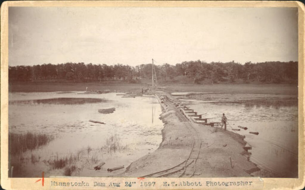
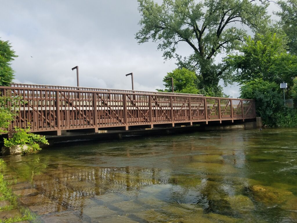
The original and central element of infrastructure in the watershed, The Gray’s Bay Dam, was envisioned from the beginning as a critical project to address historic flooding problems along Minnehaha Creek. In 1971, the District engineer provided a report on the need for improvement of the historic Gray’s Bay Dam. By 1972 the Board of Managers conceived of promoting the Gray’s Bay project as one of a set of comprehensive projects to improve Minnehaha Creek, including projects to facilitate recreational access. The District circulated the petition for creek improvement projects to all of the municipalities along the Creek and the Minneapolis Park & Recreation Board.
These communities formally submitted the petition to the District, and by September 1973, the Lake Minnetonka Conservation District, the cities of Minnetonka, Hopkins, Edina, St. Louis Park, and Minneapolis and the Minneapolis Park & Recreation Board executed a cooperative agreement in support of the improvements of the Creek and the construction of the Gray’s Bay headwaters control structure at the site of the original dam built in 1897. Further engineering work ensued on the project design, along with pursuit of regulatory approvals. The DNR approved the project, and in February 1975, the U.S. Army Corps of Engineers (Corps) issued a report determining that Lake Minnetonka and the portion of Minnehaha Creek upstream of Minnetonka Mills are “navigable waters of the United States for purposes of the exercise of regulatory jurisdiction” by the Corps. Discussions with the Corps continued into 1976 and by April 1976 the District and its partners took several steps to join issue with the Corps.
The District applied on April 27, 1976 to the Corps for a permit to proceed with the Gray’s Bay project, but also on April 29 filed a lawsuit in federal district court joined by the Lake Minnetonka Conservation District, the Lake Minnetonka Association and two private land owners from Lake Minnetonka. Their suit asked the court to determine that Lake Minnetonka and the upper portion of Minnehaha Creek are not navigable waters within the meaning of the Rivers and Harbors Act of 1899 (RHA). The DNR intervened on behalf of the plaintiffs, contending that, should the court determine that Lake Minnetonka and Minnehaha Creek were waters of the United States, the court should find permits issued by the U.S. Army Corps of Engineers (Corps) for activities on the lake to be invalid because the permits duplicated and conflicted with state and local regulations. At the time, the Corps had also asserted regulatory jurisdiction over docks, and placement of riprap shoreline maintenance work on Lake Minnetonka. The MCWD also unsuccessfully pursued a legislative remedy through U.S. Representative Bill Frenzel, who introduced H.R. 377 in early 1977, a bill to declare that Lake Minnetonka was non-navigable.
Two years later, the federal district court ruled in favor of the MCWD and other plaintiffs, holding that because Lake Minnetonka and the portion of Minnehaha Creek above Minnetonka Mills were located entirely in Minnesota and not part of connected navigable waters used for interstate commerce, the lake and the creek did not constitute navigable waters of the United States under the scope of the RHA. The court also determined that, while the portion of Lake Minnetonka and Minnehaha Creek above Minnetonka Mills were navigable waters under the Federal Water Pollution Control Act Amendments of 1972 (FWPCA), the placement of rip-rap and construction of a dam were beyond the scope of what constituted a pollutant subject to the Corps’ FWPCA permitting authority. The court further noted that local and state governmental water quality regulations were already in place for Lake Minnetonka and Minnehaha Creek, and that the Corps’ regulatory jurisdiction largely duplicated existing local and state regulations.
In 1979, the Corps appealed the U.S. district court’s decision to the Eighth Circuit Court of Appeals. On appeal, the Eighth Circuit agreed that Lake Minnetonka and the portion of Minnehaha Creek above Minnetonka Mills did not constitute navigable waters of the United States under the RHA. The waters were located in Minnesota only, and did not connect to navigable waters or enable interstate commerce, and thus the Corps did not possess federal regulatory jurisdiction over the lake or portion of the creek at issue. The Eighth Circuit reversed the district court’s decision as to whether the Corps had jurisdiction under the FWPCA, holding that the Corps did have authority to regulate the placement of rip-rap in Lake Minnetonka and the construction of Gray’s Bay Dam. The Eighth Circuit reasoned that the construction of dams and placement of rip-rap constituted discharges of dredged or fill material under the FWPCA, and that such discharges fell under the broad definition of “pollutant” under the act, which included “the man-made or man- induced alteration of the chemical, physical, biological, and radiological integrity of water.” The Eighth Circuit further determined that state and local regulatory efforts could not replace the Corps’ authority to enforce the FWPCA in the absence of an Environmental Protection Agency- approved state plan to administer dredged or fill permitting for the state.
Upper Watershed Retention
At the same time the MCWD was pursuing the Gray’s Bay Dam and other Creek improvements, it also aggressively pursued retention projects in the upper watershed to achieve larger flood protection for the area draining into Lake Minnetonka. In 1975, the District received a petition from upper watershed communities seeking comprehensive retention projects in all six sub-watersheds draining into Lake Minnetonka. The Board of Managers, engineer and attorney worked extensively with the upper watershed cities to build a shared understanding of the project and its potential benefits. The MCWD was able to obtain a federal grant from the Environmental Protection Agency to create one of the first computerized models to calculate storage potential.
With the benefit of this modeling exercise, the District engineer submitted a preliminary engineering report for the project in 1977. The report identified 21 potential retention basins and estimated that the projects could provide a total of 7,800 acre-feet of storage, equivalent to 6.7 inches on Lake Minnetonka. The engineer estimated that the cost for these retention projects would be approximately $375,500. Retention projects in the Six Mile Creek and Painters Creek sub- watersheds accounted for 70% of the storage.
The retention projects would not ultimately be constructed for some years, after lengthy contested proceedings and later condemnation actions.
Hydrologic Data and Water Quality Studies
MCWD immediately committed resources to data collection and analysis to provide a science-based understanding of the watershed. Within a few months of its creation, the District began installing gauging stations and collecting water level data, borrowing considerable equipment from the Minneapolis – St. Paul Metropolitan Sanitary District. The 1968 budget adopted by the Board of Managers included $8,000 (8% of its $100,000 total budget) for lake gauge installation, precipitation gauging stations, water quality monitors, and ground water observation wells. By 1969, the District expanded its hydrological data program and included the Minneapolis lakes in coordination with the Minneapolis Park & Recreation Board. Water quality studies also began in 1969 with an analysis of stormwater discharge to Minneapolis lakes. This hydrodata collection and the water quality studies informed the District’s first overall plan process in 1969, along with soils and floodplain mapping.
In 1971, municipalities requested the District to expand its hydrological data program and to serve as a centralized source of floodplain mapping. The District’s commitment to its data collection and analysis also clearly supported its application to the EPA for the early computerized modeling development.
Lake Minnetonka
The Board of Managers devoted balanced attention to the needs of the lower and upper watershed in these formative years. The District worked extensively with the Lake Minnetonka Conservation District to coordinate water resource initiatives relating to Lake Minnetonka. The District took an active interest in the Metropolitan Sewer improvements to improve water quality for the lake and other area water bodies. Although the District had no direct role in the funding or implementation of the sanitary sewer system, its comments on development reviews included recommendations that projects connect to the Metropolitan Sewer system.
In addition to the District’s development of plans to construct retention basins in the upper watershed, the District was invited to take ownership of Hennepin County’s groundwater wells adjacent to Lake Minnetonka. The District agreed to acquire these wells, but early on made it clear to the public that pumping groundwater from these wells provided no means for increasing the level of Lake Minnetonka.
One early regulatory focus of the District involved protection of the lake bed ecology through regulation of dredging activity on Lake Minnetonka. The District carefully coordinated its approach with the DNR and LMCD to align dredging policy. The District also engaged in active promotion of wetlands or “marshlands” protection as one means of protecting the Lake Minnetonka ecology. The District worked with the City of Orono to develop model ordinances on marshland protection which also served other lake communities.
Continue reading the MCWD history series: