
MCWD entered the new millennium taking strong stands, willing to pursue the leading and bleeding edge of water resources protection. Comprehensive studies undertaken during this period laid a strong scientific foundation to drive key events, including the underpinning of the 2007 Water Resources Management Plan (Plan). A Total Maximum Daily Load or pollutant loading allocation approach in the MCWD Plan brought more stringent regulatory standards and imposed somewhat unwelcome demands on cities. MCWD succeeded with groundwater protection at Highway 55 thanks in part to strong legislative support and failed with regulatory ideas like imposing lake buffers. The MCWD also continued to expand its vision of partnerships to include private partners such as Methodist Hospital, Duke Realty, and Bachman’s, and invested in cost share programs to promote watershed stewardship with individual property owners.
This article is excerpted from MCWD’s Historic Insights and Principles of Success publication, compiled by its Board of Managers and staff as part of a process to evaluate key events over time, extract strategic insights, and document learnings that could be carried forward to guide the future success of the organization.
Hydrologic, Hydraulic, and Pollutant Loading Study (HHPLS)
Initiated in 2000 and completed in 2003, MCWD undertook the HHPLS study to document the watershed’s physical and biological characteristics. The study combined data on water volume, quality, and other monitoring projects to model the amount and quality of water moving through the watershed. When completed, it was one of the largest H&H models in the country. However, the model ran into various technical issues, including calibration against actual creek flows measured in the field. MCWD faced pushback from cities on these technical grounds, and the project also faced significant cost overruns. In subsequent years, however, following development, feedback from communities, and calibration the Department of Natural Resources and the Federal Emergency Management Agency used it for the 100-year flood mapping for the National Flood Insurance Program.
Wetland Function and Value Assessment
In 2001, MCWD contracted with the Hennepin Conservation District (HCD) to develop a comprehensive inventory of the 4,500 wetlands within the watershed. The goal was to develop a management strategy aimed at the active preservation of these areas rather than simply post- degradation improvement. The program focused on wetlands larger than a quarter of an acre, with smaller wetlands considered on a case-by-case basis. The project made use of an enhanced version of MnRAM (a numerical model that ranked each wetland function in a traditional Excel sheet) known as MCRAM (the Minnehaha Creek Resource Method). This new model was reviewed favorably by the Board of Water and Soil Resources (BWSR). The data resulting from the assessment was used to identify high value wetlands, around which the MCWD built a wetland classification framework (Preserve, Manage 1, 2 & 3) used to drive policy and management decisions. It also included recommendations for the restorative management of already-degraded wetlands. These results were made available to all watershed cities, which had been initially skeptical about the project and concerned with how MCWD would use the tool. The results were incorporated into the District’s Water Resources Plan, and later informed the drafting of Rule M on vegetative buffers, which cities strongly opposed.
Stream Assessment
The final major assessment project of the decade was a stream assessment study, proposed in response to the destabilization of Minnehaha Creek due to stormwater discharges and bed scour. The project made a comprehensive baseline assessment of stream conditions, which were mapped using GIS, and focused on stream classifications, the identification of erosion and scour locations, habitat condition, buffers and exotics, and floodplain encroachments. Initial results in 2004 indicated that Minnehaha Creek was aggrading, rather than incising as thought, and found that excessive grade control had resulted in excessive impoundments of the Creek. These conditions had impaired aquatic life habitat through the Creek. In 2005, the assessment focused on the upper watershed, and expanded to include macroinvertebrate sampling and the creation of a physical inventory database. Overall, the assessment work resulted in recommendations for better control of stormwater flows into the Creek (by replacing stormwater sewer outlets) and streambank restoration projects at more than 50 locations. These results and recommendations were shared on the MCWD website as well as made available to all upper watershed cities.
Creek Visioning Work
Driven by the HHPLS project, the Creek Visioning initiative sought to move from data collection and leading-edge modeling work into strategically using that information to drive future projects. MCWD partnered with the United States Army Corps of Engineers (USACE) and cities to create a task force to which MCWD made nine appointments from the Citizen Advisory Committee, the Technical Advisory Committee and agency representatives to whom the results of the visioning would be useful. Much of this work built off the initial HHPLS model, expanded to model Minnehaha Creek’s full conditions. The project identified the top priorities of erosion control and support of aquatic life over the creek’s length, while also identifying issues like streambank stabilization and the need for support and maintenance of recreational opportunities. The challenge came in implementing these goals. MCWD pursued wide ranging projects that alternated between regional stormwater infiltration projects and streambank stabilization, stretching resources and time. Nevertheless, the Visioning work did provide a strong platform that led to the introduction of successful programs like the Land Conservation Program and more informed regulatory work.
Rulemaking
In early 2001, MCWD began drafting a new Rule M that removed buffer provisions from Rule D (Wetland Protection) and created a more comprehensive standalone buffer rule. The new rule would impose minimum buffer width requirements on lakes, streams and wetlands— instead of just wetlands and public waterways in Rule D—and included constraints on grading and filling, the placement of structures and surfaces, and overall vegetative disturbance. The buffer width requirements drew upon the Wetland Function and Value Assessment and based in substantial scientific literature that found demonstrated benefits for water quality, integrity of riparian edges, and habitat protection as a result of vegetative buffers.
the proposed rule faced strong opposition from both cities and the Builders Association of the Twin Cities (BATC), although some environmental organizations expressed support. A first round of opposition at a public hearing in February 2002 questioned the benefits of buffers on water quality and expressed fears that buffers would increase sprawl, reduce land value, and result in the loss of buildable acreage. Subsequently, a revised version of the draft rule was released, this time accompanied by a guidance document to clarify and interpret its provisions.
The revised draft of the buffer rule also included alternatives like grandfathering provisions, exceptions for public roads, utilities, and trails, and a Comprehensive Site Water Resource plan that cities could utilize instead of buffer requirements. Opposition persisted, however, and BATC even threatened legal action challenging the buffers as a taking and the authority of MCWD to regulate based on wildlife protection. The Minnesota Parks and Recreation Board also expressed criticism of the proposed rule and stated that it felt it had been excluded from the rulemaking process. The draft rule went through another round of revisions.
The final version of the draft buffer rule, released in late 2003, again received similar responses, especially from cities concerned about single- family properties exemptions, and BATC continued to threaten legal action. The Minneapolis Department of Public Works questioned the sufficiency of data to even demonstrate effectiveness of the rule, despite the scientific literature and local wetland assessment work. Notably, multiple environmental groups expressed strong support for the rule, including the Conservation League of Edina.
Despite efforts to work directly with cities and the creation of a task force to deal with these issues, MCWD finally decided to abandon the rule, prioritizing good relationships with the community over forcing compliance with a controversial rule. Wetland protection buffers were left as is in Rule D.
2007 Watershed Plan
Initiated in 2005, the updates to the MCWD watershed plan were envisioned as a place where goals for future rulemaking and policies were articulated and from which projects could work to achieve those goals. The objective for the plan was to organize and enhance the GIS system for the watershed, reviewing and incorporating previous floodplain mapping and the HHPLS modeling work. All elements of watershed programs and data were to be integrated, creating sub- watershed implementation plans and capital programs.
Central to this work was the development of the Total Maximum Daily Load (TMDL) approach and the creation of performance-based rules. MCWD embraced the pollutant loading approach of TMDLs to develop pollution reduction budgets for each subwatershed to meet water quality standards. This was seen as a way to reorient regulations and project planning to move proactively towards meeting water resource goals for specific waterbodies, instead of playing “catch up” and only addressing development impacts after the fact. With the support of an MPCA grant, MCWD developed load-reduction goals and plans for the waterbodies in the District and incorporated these TMDLs into the Plan. These goals were intended to be collaborative with cities, but also placed expectations, as cities would be the entities held responsible for meeting TMDLs ultimately, and not watershed districts. The approach was a “three legged stool;” performance targets were to be achieved three ways, through (1) load allocation to cities; (2) increased rule protections; or (3) MCWD capital projects. Cities often viewed (1) and (2) as unfunded mandates.
Unsurprisingly, this met with pushback from cities, although the main concern was cost and not the scientifically based goals themselves. Clarifications that MCWD would not dictate to cities how to meet these goals, and the inclusion of three ways to garner credits to reduce load requirements (including adopting a capital project, introducing Best Management Practices like street sweeping, and other regulations) mitigated the city concerns, and the Watershed Plan went on to be formally adopted by MCWD.
Some cities used the 2007 Plan as an occasion to request funding of capital projects to address local water issues. Minneapolis, for example, requested major MCWD funding to assist in addressing the federal regulatory requirement of disconnecting combined sewer overflow and mitigating local flooding issues. MCWD identified such needs generally, but not all these requests could be embraced in the plan.
It is also noteworthy that the plan had 17 ambitious goals that pushed significant expansion of MCWD’s activities. While MCWD accomplished much in line with these goals, the broad range of multiple goals reflected a lack of strategic coordination between programs and at times impacted relationships between partners and programs internally.
Land Conservation Program
Initially proposed as a possibility in 2003, the Land Conservation Program was another effort to preempt water resource degradation by taking proactive measures. The goal of the program was to preserve high quality natural areas and green infrastructure that had the potential for the protection and improvement of water resources throughout the watershed. For its development, MCWD worked with a wide range of advisory partners, including the Hennepin County Environmental Services, Three-Rivers Parks District, U.S. Fish & Wildlife, Natural Resources Conservation Service, Carver County SWCD, and Carver County Planning.
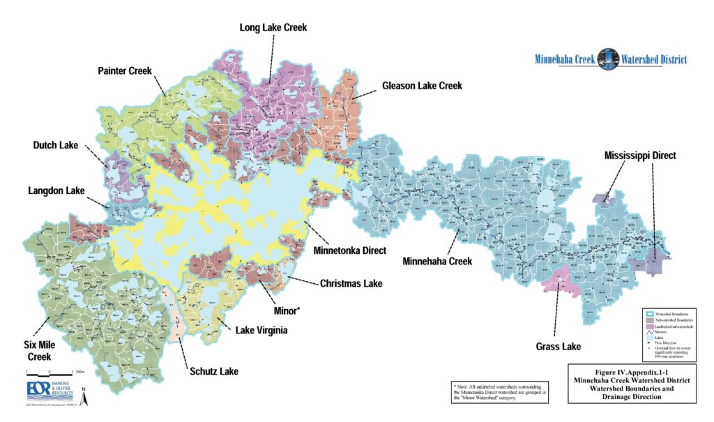
Investigative work throughout 2003 on strategies to identify appropriate target land for conservation resulted in recommendations to identify sites with (a) the highest natural biodiversity, (b) high potential for improving water quality, and (c) strategic potential to contribute to the creation of natural corridors. This strategy resulted in the identification of four “macrosites,” within which specific sites took priority due to existing natural and developed features: the Painters Creek Wetlands, Painters Creek Northwest, Forest Bluff, and Dutch Lake. Both acquisition of title and the use of conservation easements were recommended as preservation methods.
In 2004, MCWD hired a full time Land Preservation Specialist, and the program began acquiring land in 2005. Over the next five years, more than 300 acres of land were acquired for protection, multiple easement projects were utilized, and over ten thousand feet of lakeshore and creek frontage were protected. In 2006, the program secured $20 million in bonded financing from Hennepin County.
While the program had significant success, it lacked integration with the ongoing capital project planning, leaving MCWD working with uncoordinated initiatives instead of using the program to complement and support those goals. Specific land acquisitions faced particular challenges, including one large acquisition contemplated in Victoria that turned out to conflict with the city’s land use and development plans. Other cities questioned the MCWD’s use of its ad valorem tax levy or large real estate purchases. As the program moved into the new decade, these concerns remained ongoing.
Mound Downtown Redevelopment Projects
In 2004, the City of Mound began initial stages of a re-development plan for the downtown area that would include water quality issues and efforts to protect the ecological health of wetlands and waters in that area. MCWD worked with the City of Mound, the Mound Harbor Development Group, and Our Lady of the Lake Catholic Church to demonstrate the ideal approach to redevelopment, re-imagining stormwater management as an asset to create aesthetic amenities like rain gardens, rather than as a liability to divert. The end project included rain gardens surrounding the private development, sand filters at the Metro Transit stop, and experimental porous concrete at the Wolner Baseball fields. While the load reduction achieved was proportionally rather limited, the project nonetheless demonstrated innovative stormwater management techniques, and as one of MCWD’s first public/private partnerships, remained a successful venture.
Pamela Park
MCWD took on several successful water quality improvement projects over the decade, of which the Pamela Park project offered a case study in healthy cooperative relationships and comprehensive wetland restoration. When the City of Edina responded to MCWD’s solicitation of city interest in regional water quality ponding, the City and MCWD initiated a cooperative agreement, with the City handling project management and MCWD contributing financially and with restoration guidance and work. The project itself concerned 18.4 acres of degraded wetland and a 7-acre lake, with about 500 developed acres in Edina draining into the area. The lake suffered from significant sediment build up. Restoration work focused on dredging and removal of accumulated sediment, then addressed water quality issues like phosphorus removal. The project also included removal of the invasive purple loosestrife, which crowded out native vegetation that would naturally buffer water edges. Stormwater ponds and wet detention ponds were constructed to reduce erosion and manage stormwater flows. While the public and residents of the area raised some issues regarding loss of trees and creek backups, MCWD worked with these concerns directly, meeting with residents on site at times, and these concerns did not spiral into larger opposition.
Big Island Restoration Project
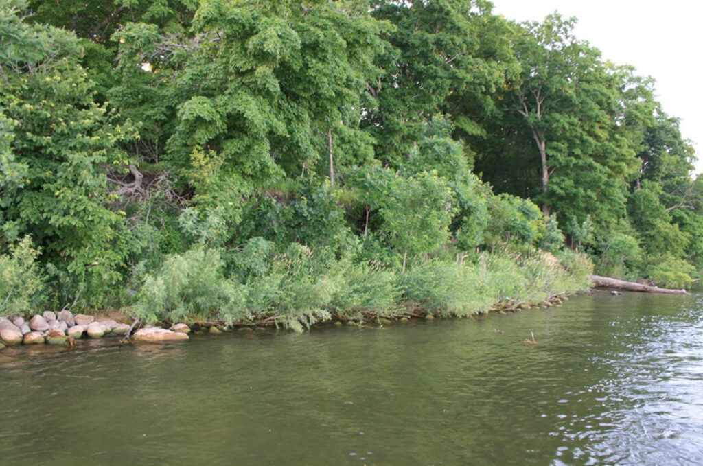
The Big Island Restoration was a large and successful restoration project achieved through a partnership with the City of Orono and the Big Island Veterans’ Camp. In 2005, the City of Orono approached MCWD regarding the purchase of the island, already having secured a purchase agreement with the Veteran’s Camp. In addition to contributing financially to the purchase, MCWD also executed a conservation easement to ensure additional enforcement of conservation goals— MCWD had previously scored the site highest among potential land preservation options due to its unique features as a large and generally undeveloped island on Lake Minnetonka. In 2005 the MCWD purchased a conservation easement from the City of Orono on 56 acres adjacent to the Big Island Regional Park and in 2009 the MCWD and Orono partnered in an effective shoreline protection and restoration project.
The project focused on wetland restoration, with an emphasis on habitat restoration as a way to improve water quality and ensure long-term land and water resource management. Restoration was divided into two main zones: the first included a cattail marsh, perched march, and the eastern beach ridge wetland, while the second focused on the restoration of ephemeral forested swamps and the isthmus beach ridge wetland. Later, stabilization of the cliffs and shoreline expanded the scope, and MCWD handpicked riprap used for installation to ensure both the functionality and aesthetic appeal of the design. While this expansion caused a significant budget increase, the end results were highly successful and saved a significant natural resource from a future that had been otherwise slated for private development.
Methodist Hospital Development
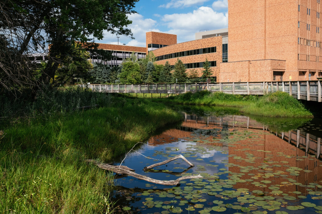
One of the first projects to begin to restore Minnehaha Creek to ecological health was the partnership with the Methodist Hospital to re- meander the Minnehaha Creek. Methodist Hospital identified its interest in the restorative, healthy aspects of access to nature for hospital patients, and was open to increasing public access to the creek through the hospital campus, while MCWD saw the site as an opportunity for creek and wetland restoration, in which MCWD would invest
$500,000. The construction included a wetland trail with an elevated boardwalk, watershed education features, and a canoe launch. By 2009 the re-meander was completed, and in 2010 re- vegetative work in the wetland was nearly completed. The project was well-received by not only the hospital’s patients, visitors, and staff, but also the general public. It remains a template reference project for MCWD that showed the enormous potential of upstream restoration.
Duke Realty and West End
Duke Realty applied for an MCWD permit for the redevelopment of a 35-acre parcel in the southwest quadrant of Highway I-394 and Highway 100, a project which became known as the West End. MCWD identified that opportunities existed at the site to achieve significant water quality benefits beyond what MCWD rules required, and for which the Board of Managers was willing to pay. Duke Reality cooperated in project design to meet and exceed regulatory standards, and MCWD provided $150,000 in funding clean water infrastructure, including green roofs, crosswalks and boulevards with porous surfaces, large underground stormwater cisterns that allowed infiltration into the ground instead of a water body, and innovative “slot storm drains” that drained water from roads under the sidewalks to water roadside trees. The results were to reduce phosphorus loading from the site by 47 pounds per year, reduce stormwater volume by 62 acre feet per year, and eventually remove downstream Brownie Lake from the Impaired Waters list.
Bachman’s on Lyndale
MCWD’s partnership with the Bachman’s at its original store in Minneapolis at Lyndale Avenue brought watershed stewardship to a visible and relevant retail setting. The project featured rain gardens as demonstration sites for stormwater management within the store campus and a succulent green roof on a garden store shed. In 2008 MCWD honored Bachman’s as an outstanding partner for including displays and demonstration sites that highlight attractive and innovative stormwater management techniques that homeowners can install.
Watershed Association Initiative
In 2006, MCWD partnered with Minnesota Waters and later with the Freshwater Society to manage the Watershed Association Initiative, which sought to cultivate watershed-oriented citizenship and to engage and empower residents to help the MCWD meet its water quality goals. In addition to getting new groups started, WAI supported existing groups to increase the effectiveness of their work, developing action and lake management plans to guide their work toward reaching achievable goals. MCWD’s support of lake and stream associations was considered unique in the Twin Cities and Minnesota. At the same time, advocacy by some lake associations led to triangulated relationships with MCWD and cities, and lake association interests in aquatic plant management and boating did not always align with MCWD priorities.
Cost-Share Iterations
In 2008, MCWD began exploring cost-share programs as a way to streamline working with partners who had identified problems and needed funding to achieve solutions. Approved by the Board of Water and Soil Resources as an element of the MCWD’s Plan, the program took shape as a three-step process: the subject (1) identifies a problem, (2) works with the MCWD staff and Citizen Advisory Committee to review solutions, (3) brings the agreed upon solution to the MCWD Board for approval. The program was incorporated successfully into the Watershed Management Plan in 2009, and split into three elements that focused on low impact development, shoreline and restoration work, and habitat restoration.312 While the program was independently successful, it was also evident of MCWD’s divergent expansion at the time, as it lacked healthy coordination with MCWD’s other partnerships and programs during this period.
Coldwater Springs and Hwy. 55 Construction
While this project began in the 90s as an effort by MnDOT to improve a commuter bypass to the Metropolitan Airport, construction impact on groundwater at the nearby Coldwater Springs and on seeps in the area resulted in a years-long conflict. Work done by the DNR in 1999 found that the area around Minnehaha Creek and the Mississippi River bluffs included many highly ecologically valuable seeps, including a black ash seep almost as rare as a calcareous fen. In the late 90s, concerns began to develop that MnDOT’s bedrock drilling and excavation work had impacted the groundwater.
In June of 2000, an unexplained four-foot drop in groundwater occurred, and MCWD began to incorporate permit requirements that required monitoring of the spring and seep waters. Local opposition that already existed due to the proposed path of the bypass through a neighborhood now also rallied around environmental concerns. A citizen petition was brought to MCWD requesting that Camp Coldwater be brought into the MCWD boundaries to increase protection for the history and ecology of the site. Eventually District boundaries were expanded to include 635 acres of land in the Fort Snelling Park area, including Camp Coldwater, but not including the MnDOT interchange.
Groundwater concerns with construction persisted, however, and in September of 2000, many of the seeps were reported dry. Independent review of MnDOT spring analyses found several issues, and MCWD issued formal complaints to MnDOT, LMRWD, BWSR and MN DNR to take further steps on the issue. Through citizen advocacy by the Friends of Camp Coldwater, in the spring of 2001 the Minnesota Legislature adopted a statutory protection of natural flow and prohibiting and state or local unit of government from taking “any action that may diminish the flow of water to or from Camp Coldwater Springs.” As MnDOT indicated its intent to proceed with construction without regard to impact on the Springs, MCWD took the step of taking MnDOT to district court, where the court enjoined MnDOT from proceeding with groundwater pumping for construction and to allow a dye test. The dye test found that the 55/62 interchange construction area had a groundwater connection to Coldwater Spring.
Finally, the Federal Highway Administration intervened in late 2001 and concurred that the groundwater connection between the interchange area and Camp Coldwater was a serious concern. In 2002 the parties agreed on a redesign of the project that included elevation of the construction bed and a liner that prevented bedrock disturbance and allowed groundwater to move through the interchange area. In addition, MCWD stressed the need for ongoing monitoring, and a 30-month monitoring plan conducted by MnDOT was agreed to, with the opportunity for MCWD to continue monitoring after that period as interested.
While the project concluded with increased attention on groundwater in the area and the protection of Coldwater Springs, MCWD’s experience confirmed the need to get involved earlier in such projects and to ensure the ability to influence design and management plans in order to better protect the resources from the start, instead of addressing problems after they develop.
Quagmire in Minnehaha Glen
In 2007, a feasibility study looked at the potential for improvement and restoration of the Minnehaha Glen and Falls area, and found issues related to stream channel repair, erosion and stormwater control, as well as accessibility for recreation and safety. Consequently, in 2008 MCWD entered into cooperative agreements with the MPRB and USACE for the design and cost-share funding of the restoration. The State of Minnesota also supported the project with funding, approving bonding that exceeded the initial request.
The design included retaining walls and bioengineering of the creek banks for the stabilization, a revitalized trail system with boardwalks and other path improvement, invasive species management, as well as new stormwater management practices at the adjacent Minnesota Veterans Home.
As the project got fully underway in 2009, however, issues with USACE and their contractor began to dog the process. Sediment filled the streambed, and there was disagreement over bad weather conditions temporarily halting the work. The State Historical Preservation Office became concerned that the trail work was impairing historical preservation in the glen and endangering cultural resources, the issue was complicated by USACE’s failure to finalize the required cultural resource review. While one element of the Army Corps of Engineers was an MCWD partner, another arm chose to treat MCWD as a violator of Corps regulations, charging that MCWD had engaged in authorized dredging and filling. A lengthy regulatory dispute ensued. Eventually as the problems persisted, MCWD internally declared the situation a “natural resources emergency.” MPRB cancelled the construction along the upper trail portion due to ongoing issues, and MCWD issued a plan of repair to ameliorate the damage caused by wall collapse and streambed sediment.
The scaled-back project was eventually completed, and while the project was successful in the end in implementing stabilization and general trail improvements, the history of its completion emphasized at best the need for more coordination and better communication in project execution, and at worst a great deal of caution in partnering with the Army Corps of Engineers.
Continue reading the MCWD history series: