MCWD entered a new era of strategic focus on integrating its mission with the missions of public and private land use decision-makers through effective partnerships. The organization underwent a significant staff change and undertook its first major strategic planning exercise as an organization which facilitated refocused direction, deeper Board engagement in governance, new staff organizational structure and attention to culture, and capacity to pursue a new watershed management plan.
This article is excerpted from MCWD’s Historic Insights and Principles of Success publication, compiled by its Board of Managers and staff as part of a process to evaluate key events over time, extract strategic insights, and document learnings that could be carried forward to guide the future success of the organization.
Himle-Horner Governance Evaluation
The MCWD retained the Himle- Horner firm in 2012 to advise the District in search of better and increased engagement in long term planning and policy work. Previous projects and programs over the past decades had been widespread and lacked a coordinated focus, and in order to better coordinate programs, establishing a clear and foundational internal structure of the District was necessary. Additionally and relatedly, general concern around the quantity of and time spent in meetings had grown as meetings themselves multiplied.
Three main goals were developed for the restructuring proposal to focus on: (1) enhancement of the public’s ability to monitor and engage with the District, specifically by addressing the confusing amount of committees and meetings; (2) achieving a better balance between policy and strategic planning compared to program management and implementation, and finally (3) the allocation of staff resources to their best use.
In response to these goals, the proposal advanced the consolidation of committees down to three streamlined versions: an executive committee, an operations and programs committee, and a planning and policy committee.334 Externally, these would be a clear and understandable organization for the public to engage with. Internally, the streamlined versions consolidated staff work and planning in an efficient structure. This supported both the balance between policy development and program management and created a clear mechanism for staff to fully utilize their respective skills.
Leadership Transition (2014–2018)
In April 2014, a majority of the Board of Managers made the difficult decision to relieve Eric Evenson Marden as administrator, after over fifteen years of serving in the position. While four managers felt it was time to change direction, three managers were strongly in support of Mr. Evenson Marden. Community representatives expressed support for him as well. While much of 2014 reflected this division of views, Jeff Spartz, the former Hennepin County administrator and former county commissioner, agreed to serve as the interim MCWD administrator. Mr. Spartz provided seasoned leadership and a strong listening ear to the staff, while also helping the MCWD move toward a permanent administrator. A lengthy and robust search process culminated in the Board’s selection of Lars Erdahl to serve as administrator in February 2015. Mr. Erdahl had a background in environmental education at the Minnesota Zoo, and served as MCWD administrator until February 2018. During this time, Planning and Projects Director James Wisker took on increasing responsibility for projects, policy development, and human resources planning. When Mr. Erdahl resigned in early 2018, the Board of Managers named Mr. Wisker as MCWD administrator. Having first joined the MCWD as an intern in 2005, Mr. Wisker was the first internal selection for administrator in the fifty-year history of the District, a reflection of the staff development and capacity over this time.
Watershed Partnerships Paper (2011)
In 2011, administrator Eric Evenson commissioned District counsel to undertake an exploration of public-private collaboration to address watershed issues. The MCWD joined with Nine Mile Creek Watershed District, the Dakota County Farmland & Natural Areas Program, and with private sector partners Allina Health and Target to explore new approaches to water resource management. Focusing on Minnehaha Creek, Nine Mile Creek, and the Vermilion River, the paper noted that each of these streams was impaired, had difficult land use issues that posed impacts to water quality and habitat, and each stream was the focus of recreational interest. Target brought direct experience in community engagement in the Midtown Greenway and an interest in great design, sensitivity to place-making, and a commitment to sustainability. Allina brought a vision of health extending beyond treatment of illness to healing communities, and a sense of strong connections between healthy people, healthy stream corridors and greenways, and healthy communities.
The paper traced the evolution of watershed management, including Minnesota’s unique creation of watershed districts, and the general absence of the private sector in watershed work. It also traced the development of greenways and conservation corridors – continuously linked tracts of land, often parks or trails, which are protected and managed for multiple uses, including recreation, non-motorized transportation, and conservation. Many greenways are adjacent to streams, and the tangible nature of greenway developments also frequently facilitates the effective engagement of the private sector. Finally, the paper considered the history of public-private partnerships, noting that the dynamic relationship between the public and private sectors is a critical quality of our democracy. It concluded with concrete recommendations for greenway partnerships along Minnehaha Creek, Nine Mile Creek, and the Vermilion River.
Balanced Urban Ecology
The Balanced Urban Ecology policy framework grew out of the vision developed in the Watershed Partnerships Paper of 2011 and became a guiding, influential philosophy for MCWD. Its goals center the need to foster partnership work with public, private, and civic partners while making decisions and plans for water resource protection and management.345 This took three main iterations: first, to join others in pursuing watershed management goals; second, to intensify and maintain focus on high-priority projects, and finally, to maintain flexibility and creativeness in adapting practices to partnership practices.
The policy reflected a distinctive change in direction for the framework of MCWD work. Projects over the previous decade had been scattered and lacked focus; this re-directed vision focused work and centered partnerships in order to do a better job of project implementation and partner communication.
2016 Strategic Planning and Program Insights
In advance of the 2017 Watershed Management Plan, the District worked to undertake work on strategic planning and program insights. The work resulted in a revised mission and vision statement that better captured and communicated the District’s goals and values: a vision of “a landscape of vibrant communities where the natural and built environments in balance create value and enjoyment; and a mission to “collaborate with public and private partners to protect and improve land and water for current and future generations.”
2017 Watershed Plan
The watershed plan for the new decade developed out of the new Balanced Urban Ecology approach of partnership, focus, and flexibility. The plan incorporated measurable goals and metrics, as well as specific drivers and strategies to accomplish the District’s key goals. Specific plans for sub-watershed plans, their respective resource issues and an implementation priority hierarchy provided a definite and strategic baseline from which the District could develop projects over the next ten years.
Central to the plan was the division of the watershed into focal geographies, including Minnehaha Creek, Six Mile/Halsted Bay area, and Painter Creek. These focal geographies were designed to guide restoration work in better coordination with partners, and to thereby consolidate the expenditure of time and resources. This initiative took shape directly in line with the Balanced Urban Ecology policy framework.
Minnehaha Greenway
The Minnehaha Greenway project was a central, multi-pronged and highly successful project that spanned the decade, including the initiatives at Cottageville Park, 325 Blake Road, the Minnehaha Creek Preserve, and the Methodist Hospital project of the previous decade. The multi-project and multi-partner effort focused on the restoration of degraded urban stretches of Minnehaha Creek and the creation of recreational access and habitat protection. Guided by the Balanced Urban Ecology philosophy, the Minnehaha Greenway project emphasized the integration of community planning, redevelopment and improvement of water resources.
Cottageville Park Development
A cooperative agreement with the City of Hopkins signed in 2014 coordinated efforts between the City and the District on a degraded area that drained into Minnehaha Creek. Restoration of the stretch included vegetation restoration of 400ft of streambank and installation of a park and recreation area, as well as an innovative underground stormwater management and drain system that captured both dissolved phosphorus and sediment from runoff. Funded by a $483,000 grant from the Clean Water Land & Legacy Fund through the Board of Water and Soil Resources, the project resulted in not only ecological restoration but also a reduction of crime in the surrounding community. The project took significant input from the community at many stages, working to incorporate local voices to guide key aspects of project design.
Japs Olson
The Japs Olson project intersection with the Minnehaha Greenway project highlights the successful nature of the District’s collaboration with private partners during this decade. Here, the company’s plans for redevelopment were integrated with District long-term goals to provide stormwater management along one of the most degraded sections of Minnehaha Creek. A letter of understanding was signed in February of 2014, which served to align visions at the start and guide project implementation, thus facilitating communication and goals to avoid the difficulties encountered by partnerships in the prior decade.
Minnehaha Preserve
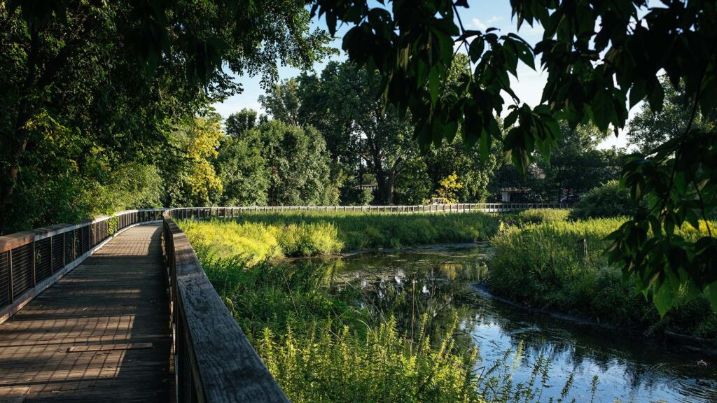
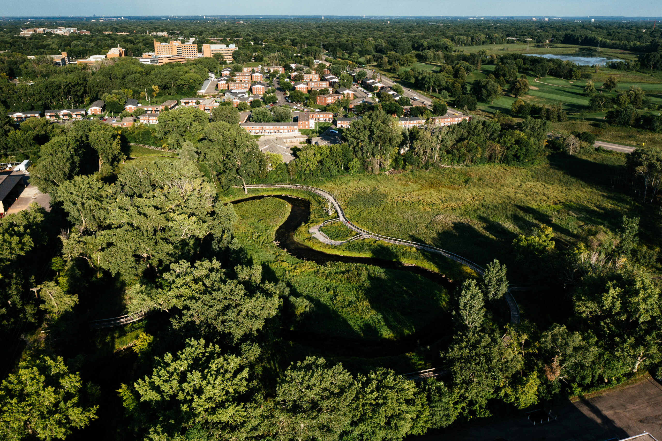
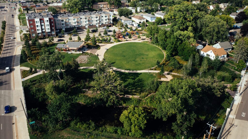
In 2010, through its land conservation program, the MCWD acquired four contiguous parcels along Minnehaha Creek on Excelsior Boulevard in St. Louis Park. At the time, the District did not have specific plans for the use of the property, but the acquisition opportunity presented itself and the Board of Managers elected to acquire the site for the significance of its location. By 2013, the MCWD took advantage of the site to construct a major restoration of this stretch of Minnehaha Creek, re-meandering the Creek by restoring natural curves and lengthening the Creek by 1600 feet. The project also treated polluted stormwater from 79 acres of surrounding area that previously flowed untreated into the creek, preventing erosion by slowing down water, creating fish and wildlife habitat, and connecting the creek to its historic wetlands.
In July 2015, the MCWD completed and opened the “Minnehaha Preserve,” featuring 2,200 feet of boardwalk and 4,600 feet of paved trail around this restored stretch of Minnehaha Creek. It became the cornerstone of the Minnehaha Greenway, now a stretch of more than 109 acres of continuous green space constructed or planned for construction along Minnehaha Creek. The Preserve quickly became a site of great community use and recreation, including outdoor education areas for schools and community groups and reconstructed canoe launches.
325 Blake Road
In 2011, the MCWD purchased a 17-acre cold storage industrial site in Hopkins with the goal of the site becoming a capstone on the Minnehaha Greenway project. The site has more than 1,000 feet along Minnehaha Creek and is adjacent to the Metro Green Line light rail transit project, as well as the Cedar Lake Regional Trail. The MCWD’s vision is to retain about five acres of the site to create access to Minnehaha Creek and treat 270 acres of stormwater runoff coming to the site. The MCWD has worked closely with the City of Hopkins to assure that the City’s land use plans and goals are incorporated into the project.
By 2018, the MCWD had obtained state and county grants to facilitate environmental cleanup of the site and complete demolition of the industrial facility. The MCWD collaborated with the City of Hopkins in a process that lead to selecting Kraus Anderson as a developer to pursue the private development portion of the site. By 2019, the MCWD and Kraus Anderson were not able to come to terms on the sale of the site and development concepts, and the MCWD elected to focus on the planning and development of the public realm elements of the site to assure that any future private developer would align its plans with the MCWD public realm.
By 2020, the MCWD and the City entered into a new cooperative agreement to express concurrence in guiding design principles and a process for collaborating in the selection of a developer for the site. The MCWD worked intensely in 2020 and 2021 to develop a strong design vision for the public realm elements of the site, which would assure that any private developer would embrace Creek access and water resource management as key design features of any development. This design work allowed the MCWD to enter a developer selection process with a much stronger vision of its goals. In June 2021, at a joint meeting of the Board of Managers and the Hopkins City Council, the MCWD and the City agreed to select Alatus as the developer for the site.
Six Mile Creek-Halsted Bay
Building on the successes and lessons from the Minnehaha Greenway, the MCWD chose to make the Six Mile Creek – Halsted Bay Subwatershed its next focal geography in applying its Balanced Urban Ecology principles. The work on the Six Mile Creek project focused on the large-scale restoration of 2,488 acres of habitat across 14 connected deep and shallow lakes. Restoration focused on the creation of restored wetland and upland corridors between these lakes, and included carp management and prairie restoration projects as well. The Halsted Bay area had been determined to require the largest nutrient load reduction in the Minnehaha Creek Watershed, which supported designating this area as one of the main focal geographies for the 2017 watershed plan.
Wassermann Lake Preserve
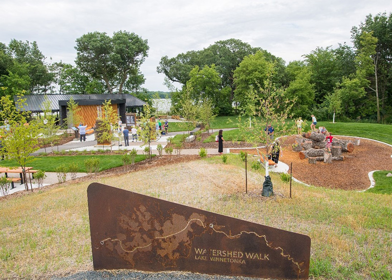
A first major project in the Subwatershed was the Wassermann Lake Preserve. In 2015, the MCWD executed a memorandum of understanding with the City of Victoria, which affirmed the mutual value of cooperative and integrated land use and water resource planning. Lake Wassermann was on the state Impaired Waters list due to invasive common carp and high phosphorus loading to the lake. In 2016, the MCWD worked with partners to establish the Six Mile – Halsted Bay Planning Partnership, which committed all partners to proactive and collaborative planning and communication about priorities. City of Victoria and MCWD staff soon identified 33.5 acres of undeveloped land on the Lake Wasserman shoreline. This parcel included Wassermann West Pond and adjacent wetlands; restoring these areas could result in significant reduction in phosphorus entering Lake Wassermann, while also providing the public access to the lake, which was a goal identified in the City of Victoria’s 2008 Comprehensive Plan. The MCWD purchased the 33.5 acres in June 2017, and then executed a cooperative agreement with the City of Victoria to coordinate responsibilities to design and construct a public park, while restoring wetland and woodland areas and implementing water quality improvements. The project was completed in 2021 and enjoys extensive public use.
Arden Park
The Arden Park project success also grew out of an implementation of the Balanced Urban Ecology policy goals of partnership and fostering of a coordinated focus on preservation and rehabilitation of water resources. The City of Edina had adopted a transportation policy to balance the needs of motorists, bicyclists, and transit riders in order to improve safety and community throughout the metropolis. As the scope of this work included reconstruction of streets, the City and the District began a collaboration to try and implement better stormwater management techniques into the project.
From there, the City and MCWD collaboration led the project to include creek improvements, and the installation of a new park facility and trails along the creek, with the District contributing around $2.3 million in project funding. The District and City worked jointly to install significant stormwater management features, including a subsurface infiltration trench under Halifax Avenue, a new and innovative pervious paver system in Jay Place, and the placement of sump manholes at three different locations within city neighborhoods. Altogether, these features provided significantly improved stormwater management along the reconstructed streets, resulting in both better safety and access for community transport as well as creek health and pollution reduction. Community residents were initially quite concerned about the project’s changes to historic park uses, but through ongoing community engagement and project adjustments, the ultimate result has been well received.
Response to Historic Flooding
In August of 2013, the Atlas 14 Report noted that average rainfall had increased an average of 5 inches over the last 50 years. The ensuing decade would go to be the wettest in the state’s recorded history.
In February of 2014, delays in melting of the larger- than-usual snowpack triggered concerns over a quick melt in mid-March and intense flooding. Concerns were valid, and spring led to wet conditions around the state. In June, this was compounded by severe high water and flooding events, as the first six months of the year broke flooding records. In September, the District contracted Wenck Associates to complete a flood assessment report, which catalogued the record- breaking precipitation and its impact on lake levels and creek flows. Of particular interest to the District during this period was the integrity of stream slopes: seven stream slopes collapsed under flooding stress, but most significantly, many streams overflowed without degradation. Examination of these stream banks later led to interest in incorporating these natural features into stream bank restoration projects.
Precipitation records of 2014 were subsequently broken in 2019. Intense flooding that began earlier in the year sparked coordination between the District, the NWS, Hennepin County Emergency Management and all 29 of the District’s communities to share information on areas with high flooding potential in order to better manage storm impact. By August, precipitation had broken 2014 records, and November marked precipitation for the year at 11.25 inches above average.
This record precipitation and related flooding sparked intensive community discussion around Lake Nokomis, where some residents were experiencing unusual flooding, and around planning for the future of the Hiawatha golf course. The MCWD served as a technical convener to address these issues in partnership with the City of Minneapolis, Minneapolis Park and Recreation Board, Hennepin County, Department of Natural Resources, United States Geological Survey, and the University of Minnesota. The MCWD produced a white paper presenting data and analysis of the Lake Nokomis area groundwater and surface water issues, and the University of Minnesota provided third party review of this paper. A productive town hall meeting to discuss the paper was held in May 2022.
Minneapolis Planning
In fall of 2014, the District began to make assessment of flood damage that had occurred on the six major creeks of the watershed during the intense flooding that spring and summer. In light of the findings, the District applied to and secured $500k in FEMA funding assistance for creek repairs.
Within the Minnehaha Creek sub-watershed, the District entered into a Memorandum of Understanding with both the City of Minneapolis and the Minneapolis Parks and Recreation Board to undertake integrated project planning of work. A key feature to facilitate this work was map sharing, where priority sites could be identified and shared mutually to develop the scope of work. Throughout the watershed, the project scope focused on stream bank repairs, especially those damaged by the high water flows of 2014 and 2015. Initially, 47 damaged sites were identified for repair, a number that was narrowed down to 11 priority sites given that several had been able to self-repair over time and others were targeted for MPRB work in the future.
Richfield Taft-Legion Development
The Taft-Legion project concerned the drainage of 1500 acres of land into Lake Nokomis, a partnership initiated by the City of Richfield. A Memorandum of Understanding was signed in 2010 that detailed key project goals to guide communication, and a cooperative agreement was completed in 2012 to further develop the partnership.
The 1500 acres that the project targeted comprised nearly 60% of the Lake Nokomis drainage area. Project features included a water reuse irrigation system and infiltration system, as well as native prairie restoration and buffer strips, pretreatment basins, grit chambers, and a flocculation treatment feature for Taft Lake internal loading. These extensive measures all worked together to improve storm water quality flowing into the Lake and creek, and were estimated to remove 187-482 lbs. of phosphorus runoff every year as well as a 130-280 acre ft. in volume reduction. These results would aid TMDL reduction goals assigned to sources even outside of the City of Richfield.
The City financed the project with $2.7 million in bonds, and provided for operations and maintenance costs, while the District agreed to make the payments on the bonds thorough its annual capital improvement levy.
Despite efforts to clarify project goals and communication by use of the MOU and cooperative agreement, the project experienced ongoing problems and significant failure to achieve the project’s performance goals. Poor historic data on nutrient concentrations that were meant to guide project design caused setbacks, and mechanical issues complicated volume reduction goals. The MCWD and the City of Richfield agreed to have the project reviewed by a different engineering firm and discussions to address these problems are ongoing.
Bushaway Road Development
The reconstruction of the intersection of Highway 101 and Bushaway Road took shape as a multi- partner project with Hennepin County, the City of Wayzata, and the City of Minnetrista. Out of these partners, a task force was assembled. Initially, the project was sparked by the City of Wayzata’s work to handle a large lakefront surface parking lot, but then grew into vision to design a lakefront landscape that restored recreational and ecological value and represented the city’s relationship with the lake.
Implementation of this vision involved the use of native plants and extensive bioengineering work to stabilize and restore the shoreline, with the goals of reducing erosion and encouraging infiltration of stormwater, as well as providing habitat and improving overall aesthetics. Throughout the project, the community voiced positive support, and participation at public meetings hosted by the District were constructive in addressing concerns and providing a platform for question and answer.
Reach 14 Streambank Projects
The Reach 14 Stream Bank projects were some of the most extensive rehabilitation of the Minnehaha reach work. Reach 14 consists of a 0.75 mile stretch of Minnehaha Creek that had poor habitat as a result of shallow water and lack of vegetation, according to a 2004 study. Accordingly, the project’s scope included 2000 ft. of shoreline stabilization, with native plantings along the bank.
The plantings required the partnership of multiple private properties riparian to the creek throughout the City of Edina; 16 landowners in total worked with the District to facilitate this work, and throughout the project the community remained strongly supportive of the project and engaged during its execution. Property owners coordinated with the District on planting design and implementation, and the project featured educational signage located along the properties in the area.
Meadowbrook Project
The Meadowbrook Project was envisioned as a joint-partnership with the Minneapolis Parks and Recreation Board for golf course redevelopment and creek restoration. The concept involved restoration of the Meadowbrook Golf Course so that the Course could handle high water events without extensive damage. Additionally, 7-9 acres of wetland restoration and creek re- meandering at the Course would continue District work along Minnehaha reaches 19 and 21.
A cooperative agreement was signed with MPRB in 2015, which outlined scope of work and mutual goals to facilitate communication during the project. The project included a budget total of $9 million, with the District work totaling $1.5 million. The MPRB decided not to go forward with the project as it further contemplated budget and golf course policy issues.
Master Water Stewards Initiative
In 2013, the District contracted with the Freshwater Society in a grant agreement with the Board of Soil and Water Resources to implement the newly developed Master Water Stewards program. Developed by the Freshwater Society, the program was modeled off the Master Gardener’s program and aimed to educate individuals who could then encourage and teach others in their communities how to effectively manage stormwater on their own properties and promote the message of water resources stewardship.
Candidates go through a program of extensive training and practical implementation. Based in social networking, the program curriculum was designed to broaden the implementation strategies used to meet the Clean Water Act Municipal Separate Storm Sewer System requirements for cities and the District. Upon completion, candidates receive a certificate that authorizes them as Master Water Stewards, creating a pool of volunteers and educators throughout the District communities.
In its first year, the program focused on the Chain of Lakes area and eastern region of the watershed, with the goal of shifting the focus westward across the District as the program expands.420 Statistics from the first year indicated that over 4,761 gallons of water had been captured in a one-inch precipitation event alone, using the 14 Best Management Practices constructed by and in collaboration with the Master Water Stewards.421 Additionally, 7542 feet of drainage area was captured.422 Freshwater Society assumed full responsibility for the program in 2019 (check), and to date, 277 master water stewards have undertaken over 80 projects and have contributed to infiltration of over 1 million gallons of stormwater.
Continue reading the MCWD history series: